
Help support this site by using our Amazon or Six Moons Design buttons for any purchase
Random Thoughts on Refugios (Albergues, Auberges), etc.:
On Refugios - a good experience, but unnerving at first. In 2001 at Roncesvalles it was chaotic for us. Some tolerant and helpful staff eventually found us a spot. However, it is all better now, a different building and assigned beds. Note: as soon as you arrive in Roncesvalles, make a dinner reservation in one of the two restaurants there. They have limited capacity and fill up.
 In refugios with
multiple rooms, sometimes they keep a few rooms locked, and
open them late, for latecomers. If all beds and mattresses are
taken, many refugios will let you sleep on the floor. A
backpack pad is useful for that. On our trip, which was Sept -
Oct 2001 (yes, during 9-11, but that's another story), we would
usually get in around four pm, and never had to sleep on the
floor. In several cases, the refugio was full and there was an
overflow facility available.
In refugios with
multiple rooms, sometimes they keep a few rooms locked, and
open them late, for latecomers. If all beds and mattresses are
taken, many refugios will let you sleep on the floor. A
backpack pad is useful for that. On our trip, which was Sept -
Oct 2001 (yes, during 9-11, but that's another story), we would
usually get in around four pm, and never had to sleep on the
floor. In several cases, the refugio was full and there was an
overflow facility available.
The refugios
are unisex, and in some cases you will find yourself in a
different room than a traveling companion. Many people snore -
earplugs help. Also, many people like to start very early so
they get to the next refugio early. Expect to hear a lot
of noise from people getting up starting around 4:30. (If you do
get up this early, you will miss seeing the beauty of much of
the trail, and stand a good chance of missing a yellow marker
and getting lost). The trail is well marked in the
country, but you need to pay attention. Marks consists of
splashes of yellow paint on rocks, building corners, etc. There
are widely spaced official markers.
There was hot water in all but one refugio, and all bathrooms
had toilet paper. One small refugio had no bathroom - just a
field (we did carry toilet paper). There are public fountains
in almost all of even the small towns, and the water is
perfectly safe to drink. Spain is a first world nation. Your Confraternity of St. James guidebook will tell where to find the
fountains.
Where to Start:
Even if you don't have enough time to walk the entire Spanish path, I recommend starting at St. Jean Pied de Port or Roncesvalles, and walking to the farthest large town that fits your schedule (Pamplona, Logrono, Burgos, Leon, Astorga). The first part is too beautiful to bypass. Come back another time to continue. If the weather is likely to be bad, start from Roncesvalles. Otherwise, take the route Napoleon over the Pyrenees from St. Jean, and book a reservation at the Orisson gite, 0638269738, about 6 miles out of St. Jean, and half of the total vertical gain in elevation. The next day will be an easy walk to Roncesvalles. You should call a couple of days in advance to be sure of a place at Orisson www.refuge-orisson.com . Note: 5 April 2007, a pilgrim died from hypothermia on the route from St. Jean to Roncesvalles. He was traveling with two others, but in the intense fog they became separated, and he went the wrong way - was found lying down in waist deep snow, alive, but died as he reached the hospital in Pamplona. Rescue was hampered by fog and snow. Every few years pilgrims die on this route due to cold and exposure, some in March or April.
Recommended Detour
Shortly before Obanos there is a detour to Eunate, a few kilometers off the Camino. We missed this the first time, and regretted it for many years, until we were finally able to visit it coming down on the Somport route. Very worthwhile.
Pilgrim Passport or Credential:
You need this document to use the refugios. You can get
the church issued document in Roncesvalles, the pilgrim office in St. Jean, or the cathedral office in the large cities.
You do not have to be Catholic. You will have to designate the purpose of your pilgrimage as religious, spiritual or cultural. If you indicate cultural, you will get a different completion document in Santiago. The guidebooks have detailed info on where to obtain a credential. Each night get
it stamped where you stay. At the moment various organizations issue credentials, but starting in 2009 you will have to use the official church issued credential for admission to church sponsored refugios and to obtain the compestela. In Santiago, show it to the pilgrim
office by the cathedral and if you have satisfied the
requirements for the pilgrimage, they will issue you the Latin
certificate of completion or compestela. The minimum distance to
qualify is walking the last 100 km to Santiago. If you start your pilgrimage near the minimum
distance, you need to get two stamps per day to qualify.
Credentials can be obtained from various pilgrim societies such as American Pilgrims. Go to www.americanpilgrims.org - scroll down the home page for the link, and request 6 weeks in advance. You can also get one from Ivar's Camino Forum.
Miles/km per day:
We averaged about 12.5 miles per day (20.8km) just counting our walking days from Roncesvalles to Santiago. Had a layover day in Burgos and Leon. We were among the slower pilgrims. Others were striving for something like 30km per day. There are refugios or other places to stay every 15 to 20 kilometers, so you can go at a slower pace, and I recommend it. There is much to enjoy if you aren't focused on getting to the next refugio. If we do it again, we would have a layover day in each cathedral city. The big problem with that is the people you have been seeing continue on.
My Blog entry on planning for long distance hiking
http://timecheck00.blogspot.com/2008/10/long-distance-walk-planning.html
Our spreadsheet of Camino Francés route with towns, distances, elevations:
Don't use as your only guide, as I may have typos, varied the route a little, etc. When you click on this, go to the bottom and click on edit to get a google spreadsheet view you can save as an xls file. docs.google.com/spreadsheets/d/1a4-6W2Kk4kgo-MViIOVY6Yk9uf6bWMElGZcQci1wUbs/edit?usp=sharing This is for our 2001 trip, and the route has changed a little since then. You can copy and use, but check distances against your guidebook.
Elevation Profile of entire Camino, distances, places to stay:
http://www.godesalco.com/iphp/perfil.php This link is so useful I listed it separately. You can select any two points between Roncesvalles and Santiago and it will generate a profile that you can print. In addition the initial display shows cumulative distances so you can calculate distances between any two points, and the next display shows distances between each place with accommodations. This information can be downloaded as a spreadsheet. Once you have the spreadsheet, you can add columns converting kilometers to miles.
When to go:
The normal "season" is from April though September. People go
throughout the year, but you can expect snow and harsh weather
during the winter months. June, July, Aug are the busiest
months. Our choices are April-May or Sept-Oct. For winter
pilgrimage information check Amawalker's blog entry on winter pilgrimage. On Dec 14, 2008, for example,
it was snowing in Leon:
For a blog on a winter pilgrimage starting from Aix-la-Chapelle
where Germany, Belgium and the Netherlands meet,
look at http://winterpilgrim.blogspot.com/
Holy Year Definition
On holy years there will be many more people on pilgrimage. Saint James day is July 25th, and if that falls on a Sunday, that year is a holy year.
Weather:
Expect some rain, particularly in April-May and mid Sept - Oct.
For example, Pamplona, from the site below, averages 10 days of
rain in April. If crossing the Pyrenees in early or late season,
talk to the pilgrim office in St. Jean re whether taking the
high route or the road route is appropriate.
If you check our gear page, you will see that we carried a rain
jacket, pants, and pack cover. Now we have a combination rain
jacket pack cover (google for packa) that works well. The packa
is only available for US sales. You still need rain pants. The
Packa now has taped seams www.thepacka.com . You can get a similar garment but
knee length - the Altus rain cape at caminoteca.com/en/rain-protection-equipments/672-poncho-altus-atmospheric-s3-s-red
Money:
ATMs in all
the larger towns - i.e. every 3 days or so. We used one of those
debit cards that can also be used as a VISA card. You will have
a numeric keypad to enter the pin number, so you need a numeric
pin number or know how to enter your alpha pin on a numeric pad.
I suggest you ask your credit card company for a credit card that has a chip in it, as used in Europe. You probably will only be able to get a Chip with Signature card instead of a Chip with Pin card, but at least getting the chip means your card will be read in the usual manner (stuck in the bottom of the reader) rather by the magnetic strip reader on the side of the device. The magnetic strip reader in Europe is seldom used so will be dirty, give bad reads, etc.
Internet Access:
Many refugios now have internet. However there are a lot of pilgrims contending for use, and they are usually Windows xp and the usb ports and/or cd drives may not be available. There are also internet cafes in the larger towns, as well as in the library. The word for internet cafe in Spain is locotario. Uploading photos can be a problem: See tourradar.com/days-to-come/store-photos-while-travelling/ for some of the problems. Most places now have Wi-Fi and we have started carrying a 3rd generation wireless only ipod to do our email and simple web lookups.
Health Care:
During 2004 Holy Year you could get a health card that provided free pilgrim health care on the Camino. That was only for holy year. The Confraternity of St. James guide reports that Cruz Roja (Red Cross) centers provide free emergency care for pilgrims. Refugio hosts and other pilgrims will give you help and advice on caring for blisters and other typical walker's problems. Check to see if your current health coverage needs anything special to cover major medical emergencies while traveling in Spain. There are some long threads on traveler's medical insurance on ivar's forum caminodesantiago.me/community/threads/medical-coverage-on-the-frances.49026/#post-530084
Re: Language:
We met very few English speakers the whole trip, no Americans till Santiago. Didn't hear English for 3 or 4 days, then met a woman from England, saw her a couple of days. Some Germans spoke English, crossed paths for several days with a woman from Santiago who spoke excellent English. A couple walking from Holland spoke English. We have zero French or German. Our Spanish is ok for travel but not for extended conversation, so for example, we traveled quite a few days with a woman from Brazil who spoke no English, and marginal Spanish. We became good friends, but had to rely on translators every few days. We heard more German and French than Spanish for the first two weeks. Once into Galicia, there were a lot more Spanish pilgrims. We started out with one of those $30 translators but abandoned it at the 2nd refugio - to slow - our fractured Spanish worked fine.
Where to stay and what it costs:
If I knew you personally, I would insist that
you get the Confraternity of Saint James publication csj.org.uk/product/camino-pilgrim-guides-camino-frances-saint-jean-pied-de-port-to-santiago-de-compostela-2018-19 as
your bible of food and shelter location and cost. You can get
this info from the web with a lot of work.
If you are looking for a little broader range of accommodations, we have
found that the excellent James Brierley guide, the Moon guide or the Village to Village guide list more of the little
hotels.
Accommodations change frequently. To cross check, I look at booking.com for higher end places or gronze.com for pilgrim lodging.
My 2019 estimate of average cost per day - one person, just
staying in refugios, buying lunch materials and buying supper,
about 35€. This would be 15 for refugio & breakfast, 6 for lunch
material, 12 for supper, 2 for etc. I think absolute minimum if you buy no meals
would be 20€. I've seen 10 quoted, but that would mean not
contributing enough to the refugios to cover their cost. A small
hostal (small hotel) room for two will be about 60 to 90€.
A 2013 list of refugios, price, distance compiled by Ivar's Forum members: caminodesantiago.me/camino-de-santiago-guides/albergues-on-the-camino-frances/
Camping:
We haven't camped but have seen tents outside of
some of the refugios. Amawalker discusses camping, and has a
list of campgrounds along the Camino:
http://amawalker.blogspot.com/2008/08/camping-on-camino-frances.html
Short Video on GR65 and Camino de Santiago Scenes:
If you have high speed internet, these are some of our images from walking the GR65 in France and the Camino de Santiago: http://www.youtube.com/watch?v=FoMjJZKEfjg
Bedbugs
There has been a problem with
some of the refugios having bedbugs in late season. I don't have
any tested advice on this. During our trips we
mostly stay in hostals unless the albergue is the only choice and don't have problems, but
hostals are small hotels with fresh sheets when you check in. We do spray the exterior of our backpacks, our sleeping bags
and our hiking clothes with Sawyer Permethrin Pump Spray or the
equivalent.
Others have reported carrying a small bottle of lavender essential oil, sprinkled on refugio mattress and
pillow with a few drops, as well as covering the pillow with a
towel, and didn't have any bedbug bites.
Cell Phones
From Richard on the now vanished Santiagobis with still accurate advice: If you want to buy
a phone that will work in Europe and the US, you can find a used
one on ebay. Search ebay for GSM Phone Quad Band Unlocked - be
sure the charger works for both 110 and 220 - read the fine
print or get email from seller to verify. Charge it and leave it
on a day or so to test it. Once you get to Europe, buy a SIM
card to get a local number and some minutes. You can add minutes
later.
You can get one of your old smartphones unlocked by the vendor, and use it the same way.
Cell Phone Rental with pickup and delivery at Madrid Airport:
This service was recommended by Rebekah on the
GoCamino forum many years ago, but link still looks valid. http://www.onspanishtime.com/web/
We now use T-Mobile and continue to use our home phone number. The only issue is that if a place wants to call you back, it is an international call (so don't expect call backs). We normally have our phone in airplane mode and just use it for photos and navigation apps such as maps.me or the Wisely Wise Pilgrim apps that work in airplane mode.
iPhones,iPads, GPS Apps
December 2014 note. Just read an excellent blog post by Jackie Laulainen if you have an iPhone, and useful for any smart phone: http://thebudgetmindedtraveler.com/iphoneabroad/
April 2012 note. This is all covered very well
in a thread on Ivar's caminodesantiago.me
April 2013 note. Ed Chandler covers all the details on how to use your iPhone in wireless only mode (free) in this facebook post to the American Pilgrims group:
https://www.facebook.com/groups/57453722347/10151472627802348/ - the essence is to set your iPhone to airplane mode, which turns off all 4 of the iPhone radios, including cellular, the one that runs up charges. Then turn back on only wireless.
Getting There and other transportation comments
For the first overlook of getting from anywhere to anywhere, we first check rome2rio.com . You can zoom to bus schedule and website or to taxi phone numbers
We flew to Madrid, train to Pamplona, bus to
Roncesvalles. Others taxi from Pamplona to St. Jean. There is seasonal bus service to St. Jean from Pamplona, but don't have the dates yet.
The Pamplona train station is in the Plaza de la Estación (District of San Jorge) Northwest of the city center across the river. From there you can take the Number 9 bus to the city center. The bus station is in the city center. The bus station is at Calle Yanguas y Miranda, As of Nov 2019 the bus leaves for Roncesvalles Mon-Thurs at 3pm, Fri at 6pm, Sat at 4pm and no Sunday service. Special hours during holy week. I got this info starting with Rome2Rio and following links.
For checking or booking bus service schedules and rates all over Spain, go to the ALSA bus line site www.alsa.es (an English button is on home page).
If you are in the Barcelona area you can get to Pamplona by bus
or train from Sants station near the airport (Sants Estació) .
The bus service is not ALSA, but is: http://www.vibasa.es/ . You
can also fly via Iberia iberia.com/us/flight-search-engine/ . Costs on
the order of 120 Euros.
There is no point in going to Roncesvalles late as the refugios close at
10 pm.
From London:
fly to Biarritz then train to Bayonne (see Rome2Rio) walk across the Bayonne bridge to train station.
Train ride is 1 hour to SJPP 4 times a day in summer.
If you start from St. Jean you don't have to go all the way to Roncesvalles in one day. There is a refugio in Huntto and a few miles after that is refuge-orisson.com/en/. If you want to stay there reserve in advance:tel: 06 38 26 97 38 or email them (see their Contact US).
From Pau
From Pau you can take a taxi to St. Jean for about 200 euros - a 1 1/2 hour drive, if you reserve in advance. I found this Pau taxi site by googling so can't verify anything about it:
http://diy-hols.com/Pau_airport_transfers/pau_airport_taxi.htm
From Madrid to St. Jean
You can fly to Biarritz then by train as above. You can train to Pamplona and then bus as above.
From Paris to St. Jean, Paris to Santiago, Bayonne to St. Jean, etc. etc. etc. I've deleted all my more detailed paragraphs, as Rome2Rio now gives just as detailed information.
Errecaldia (St Jean b&b) directions on how to get to St. Jean
This page gives directions for all over Europe to St. jean errecaldia.com/findus.html . It also gives a link to http://www.expressbourricot.com/ a baggage service that provides various services including shuttling pilgrims from Roncesvalles to St. Jean.
Trainline - a popular destination for train and bus tickets
If you don't want to negotiate train and bus sites in their native language, Trainline is another alternative thetrainline.com/en-us
Luggage Storage in Santiago
This is a new service as of 2013 - Ivar, the owner, has been running an excellent pilgrim forum for years. www.caminodesantiago.me/luggage-storage-in-santiago-de-compostela/
Airline Schedule for Spain:
Interactive Madrid Metro Map(select the flash format): http://www.metromadrid.es/es/viaja_en_metro/red_de_metro/planos/index.html
The airport is on the pink line towards the right. Move the mouse and the names will become large enough to read. The Atocha train station is on the blue line a little down to the right from the center.
Camino Statistics on Travelers
Look at the oficinadelperegrino.com/en/statistics/ for camino statistics by
month, year, age thru 2014. In brief and rounded for 2014: June
33000 - July 39600 - Aug 51200 - Sept 34500 - Oct 23200 - Nov 4800. For 2013, Ages under 30
61114, 30-60 121305, over 60 33461. I think age distribution is misleading in that
many young people join the Camino in Galicia. The
statistics for Roncesvalles to Leon would show an older set of
pilgrims.
Trends of annual totals:
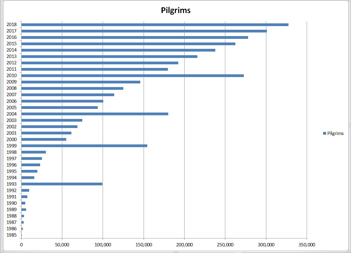
Sex 55% men, 45% women.
Reason for pilgrimage: in 2013, 40% religious, in 2004 75%
religious.
Translation Hints:
A number of good European sites are not available in English. I use Google Translate. With that, when I am on a foreign language site, I click Translate this Web Page, and I can navigate thru the site successfully.
Other Interactive Sources of Information:
Ivar's forum - http://www.caminodesantiago.me/board/ As of Nov 2019, this is the most active English language forum that I have found. You can count on a good response to a query in 24 hours.
American Pilgrims Facebook Group - this is becoming one of
the more important places for at least United States based
pilgrims. Lots of posts daily, but hard to find anything from earlier posts due to Facebook's poor search capability.
There are also many local chapters of American Pilgrims. Our one here in Northern California has multiple events per month, open to all: facebook.com/groups/Peregrinos.Northern.California/
http://www.elcaminosantiago.com/ is an old site by Grant Spangler.
He has has
a wealth of Camino information - maps, routes, train and bus
schedules, but don't know how current it is.
http://caminodesantiago.consumer.es/ in Spanish -
interactive map with all routes, click on a route to get day by
day stages (etapas) and kilometers. Also has alburgue info for
each stage.
Bicycle Links
American Pilgrims has a Facebook Group on Cycling practical info on bicycling the
Camino - gear, etc.: facebook.com/groups/CyclingAmericanPilgrims/
This site in Santiago rents bicycles and will deliver them to
your start point, and you ride back to Santiago to return them.
They also rent bicycle gear. Roughly 320 euros for 2 bikes, 12
days. All this info per email from Steve. We haven't bicycled
ourselves. http://tournride.com/
Easy to read for a quick overview of bicycling the Camino and
general Camino info: http://www.goxploring.com/camino/
This site appears useful, but more so if you read Spanish: bicigrino.com/en/camino-frances.html
Camino Related Blogs of Interest:
These are all blogs I try to follow.
http://moratinoslife.blogspot.com - Rebecca's saga as she
and her husband move to Moratinos, a Camino stop on the meseta,
and restore an old house. I recommend starting from day 1.
http://verylongwalks.blogspot.com/ - A couple who walked from
London to Santiago.
http://www.vfpilgrims.blogspot.com/ - Sil's blog - a walking
pilgrim - has walked the Camino, walked to Rome and walked other
pilgrimage routes.. Also
contributed the Via Francigena info I have below.
http://winterpilgrim.blogspot.com/ a woman starting in early
December from Aix-la-Chapelle where Germany, Belgium and the
Netherlands meet.
American Friends of the Camino
This active organization of mostly U.S. pilgrims sponsors an annual meeting, has an informative website: http://www.americanpilgrims.com
The Annual Pilgrims Gathering
These annual gatherings are during college spring break. There is also an associated hospitalero training session before the session and a spiritual retreat after. For more information, americanpilgrims.com/events/events_national.html
Sound Links:
The Spanish sound site: http://www.escoitar.org/ has many sounds, one of the comments posted on the site contains the sounds of the Cathedral bells, with the sound of water falling in the praza de platerías xunto a fonte dos cabalos. To get there: Click and you get a google map. Below the map are three boxes. Put A Corona in the Province box, then Santiago in the Comarca box. Put berenguela in the 3rd box and hit the pesquisar button. That brings you to a bunch of sound comments. You want the one that says Miguelangel says on Nov 21, 2007 @ 08:01 AM: Right now it is the 3rd comment. Click the play button. Thanks to GoCamino's Rosina for the heads up about this site.
Video Links:
You can google for camino de
santiago under the videos tab. Also YouTube has some, including
ours. YouTube video quality is poor, but we put together a 3
minute video that gives you a flavor of the Camino and GR65. For
a high quality presentation, come to our show when it is in your
area. For the YouTube video, click below:
Youtube Walking the GR65 and Camino de Santiago
Documentary on six people walking the Camino in 2009:
http://www.caminodocumentary.org/
Other Links:
I've listed this link earlier, but am repeating it because it is
very useful:
http://www.godesalco.com/iphp/perfil.php You can select any two points
between Roncesvalles and Santiago and it will generate a profile that you can
print. In addition the initial display shows cumulative distances so you can
calculate distances between any two points, and the next display shows distances
between each place with accommodations. This information can be downloaded as a
spreadsheet. Once you have the spreadsheet, you can add columns converting
kilometers to miles.
Confraternity of
St. James - a good planning resource and the source of must have Camino
guide as well as guides to some of the other routes.
http://www.mundicamino.com/ingles/ is a good site particularly when you need details on one of the more obscure
routes
www.pigrimsprocess.com publishes
several Camino books, all by Eyln Aviva - one a story of her Camino journey, and
a couple of novels in the setting of the Camino. I'll put more info in the
books section once I get a chance to read them..
http://www.pilgrimage-to-santiago.com/ This is a site in English dedicated to providing information on the city of Santiago de Compostela - it's been up since about May 1st, 2004 and so far looks good. (in
2004 was called santiago-today).
http://www.caminolinks.co.uk/ This UK site is has a well organized set of
camino links including links to private journals, to Camino del Norte and Via de
la Plata, which I do not cover.
caminoadventures.com/ Leslie's UK site has a wealth of information, including articles by other
pilgrims, and a nice set of photos.
http://www.ourcamino.com/ This
Camino site is maintained by Jim and Eleanor Clem, authors of Buen Camino, which
I enjoyed and reviewed earlier. The highlight of this site for me is the
excellent photo section. It also covers the books well.
http://www.robertward.ca/index.html - Robert Ward is the author of two
pilgrimage related books. Virgin Trails is about his search for the holy places
of the Virgin Mary, and All the Good Pilgrims about his Camino tales. Check his
site for more information.
http://onfootinspain.com/ - Nancy Frey
and Jose Placer founded this well regarded walking tour company in 1999. A good
choice if you are looking for a knowledgeable, guided walking tour on the Camino
or other parts of Spain and Portugal.
Check out the Online Telegraph bookstore - informative
overall Camino web site in English. Not recently updated.
http://timelines.ws/countries/SPAIN_A.HTML - a timeline of Spanish history
and related related links for those who want some historical background.
If you want to study Spanish in Santiago de Compostela, the following link looks
good, but we have no info other than the link:
http://www.spanish-university.es/santiago-spanish-course.php
Photo Links: Just enter Camino de Santiago photos into
the Google images page and you can get a lot of
good trip photo links, so I won't duplicate them here. Same thing for alltheweb
images page.Also the caminolinks site above has a good photolinks section.
A slideshow of Camino pieces from the Victoria & Albert Museum: http://tinyurl.com/38udep
Canadians - Little Company of Pilgrims Canada
There is an active society of Canadian Pilgrims. See http://www.santiago.ca/ for more information. They are sponsor annual pilgrim gatherings open to all pilgrims. See the website for more information.
Google Earth routes, GPS Points from Le Puy to Santiago:
This website collects all the various gps info and google earth paths into one spot: http://users.skynet.be/watermael/gps/50358.html
Maps
From Roncesvalles on the yellow path markings are good enough so that a map is not
essential. It does increase the comfort level. From St. Jean to Roncesvalles by
the high route, most of the way is on small paved roads, but near the top you
need to pay close attention, so read the various guidebook instructions, stop at
the pilgrim office in St. Jean, and get their little map, and don't go over in
the dark or heavy fog. You will miss spectacular scenery if you do. The Brierley guide has useful maps in an
English language guidebook. The Moon Guide to Camino de Santiago printed edition, in addition to being an excellent guidebook, includes a removable folding map at the back, which I would pay $10 for by itself. We also got Michelin maps but didn't get much use
out of them. There is a flimsy Spanish language map of the Camino that you
can buy in bookstores in major towns along the route. Also, try the University of
Texas public domain maps: http://www.lib.utexas.edu/maps/
Ediciones Way publishes maps you can buy in bookstores in Spain. Fold to 3 1/2
by 3 1/2 and have distances, altitudes, refugios, etc. There is one that
covers the Camino from SJPP to Burgos, and Somport to Burgos; another from
Burgos to O Cebreiro and another from O Cebreiro to Santiago.
The name of the map series is "El Camino Jacobeo en tu Bolsillo"; ISBN
84-930395-2-7 in Spanish, French, English and German. I've heard they may
be ordered from the publisher: ;Ediciones Way, S. L.
San Anselmo No. 1
2818 Madrid
Spain
Medieval Pilgrimage - further information
This scholarly site has a wealth of information on pilgrimage in the middle ages, including many images: http://peregrinations.kenyon.edu/
Camino Gear List
Google Docs Primitivo Gear list
Other Pilgrimage Routes in Spain:
Confraternity of St. James Guides available online for Camino Inglés, Finisterre and Camino Portugués
You can download any of these guides as a word file, which you can edit, or a pdf file which cannot be edited. A donation is expected. See: caminodesantiago.me/camino-de-santiago-guides/
Camino del Norte:
Camino del Norte is a less traveled route that was originally used by pilgrims from England. We have a separate page on this route, as we spent several years on it, and one of Susan's books is about it. Norte Primitivo routes
The Primitivo Route:
Also on our northern routes page: Norte Primitivo routes .
Vía de la Plata
Starts from Seville and joins the Camino Francés at Astorga. 734
km to Astorga. See Confraternity of St. James routes page: http://www.csj.org.uk/routes.htm
An alternate starting point for this route is Granada, joining the main VDLP at
Mérida. This alternate leg is called Camino Mozárabe.
We walked part of it to Córdoba in spring of 2011. I did a blog entry on Planning for Camino Mozárabe as well as a trip report on Camino Mozárabe. I also did a couple of youtube videos on
the trip. On on the Camino
Mozárabe route, and one on the Colors of Andalucia. There is an excellent thread on Ivar's forum that includes a pdf spreadsheet with all the stops. Be sure to read the entire thread and download the spreadsheet: http://www.caminodesantiago.me/board/via-de-la-plata-albergues-pensions-and-hostals/topic17077.html#p122989
There is a very good pdf guide to Camino Mozárabe including three different starting points:
caminomozarabedesantiago.es/documentos/guia-eng.pdf
The Camino Portugués:
On our Camino page 3 we have some notes from our Portugal walk.
GPS Usage
A gps is not needed for Camino Francés. For some of the other routes it could add some comfort. We have the free maps.me app on our smart phones, and use it in airplane mode. The maps have to be preloaded when you have a wifi connection, so we do that before leaving home. GPS tracks can be loaded as maps.me bookmarks. I do this for any route we are hiking. It is sometimes difficult to find them. However, the Vezelay route we are currently doing has free guidebooks, accommodation lists and gps tracks, both in Dutch and English. They have GPS tracks for almost all pilgrimage trails. santiago.nl/downloads. The published tracks always have a few differences from the current route, so you do need to have other ways of confirming the route. We also use the paid app Gaiagps, which has detailed topo maps, but using in airplane mode takes planning.
The route from Somport to Puenta de la Reina
This site is in Spanish, but still helpful for those who wish to travel this beautiful and lightly traveled route: www.jacajacobea.com. This is part of the route from Arles, France, my favorite of all. Near Jaca is the wonderful San Juan de la Peña - a monastary carved out of a cliff. Not right on the trail, but be sure to see it. Take a taxi from Jaca if you don't have time to walk up to it.
The Route from Arles, France
We gathered so much info on this route in preparation for our
trip, that we gave it a separate page:
backpack45.com/arles.html
A link to all the GR routes in France
http://www.gr-infos.com/gr-en.htm
Other hiking routes in Spain:
I sometimes get questions about other long distance trails in Spain. The European E4 hiking route goes along the east coast of Spain as part of its route.
John Hayes has walked the E4 from the southern coast of Spain to Hungary, and has a good blog about it: http://www.johnhayeswalks.com/p/e4.html
Other Pilgrimage Links:
The Via Francigena From Canterbury to Rome:
March 2007 - Sil from Santiagobis tells
me that there is now a Confraternity of Pilgrims to Rome: pilgrimstorome.org.uk/index.html
http://www.eurovia.tv –
Website of the Association for The Establishment of European Pilgrimage Routes.
Current Project is the pilgrimage to Rome. This association issues pilgrim
identity cards for the Via Francigena
Sil provided all of the following (Nov
5, 2006):
The two most active organizations are:
(AIVF) Association International Via Francigena: www.francigena-international.org (Website in 5 languages)
Based in Rome – started by Adelaide Trezzini in 1994. You can become a friend (AMIS)
by joining the Association. You can buy their accommodation and monument guides
called the Guida Vademecumum – one for Canterbury to Gr St Bernard and the other
from Gr St Bernard to Rome.
They also have maps called Topofrancigena for these two regions. Adelaide
recently provided an excel document called the Dormir-Francigena with additional
information on accommodation. Members receive a `pilgrim passport' to have
stamped along the way and if you walk the last ± 140km from Aquapendente, you
will receive the Testimonium in Rome.
(AEVF) Associazione Europea della Vie Francigene: www.associazioneviafrancigena.com /
(Website in Italian and English)
Founded in Fidenza in 2001. Not yet a membership organisation for pilgrims but
you can register on-line to receive their monthly e-newsletter (Italian).
The website offers Interactive maps, about 300 excellent (1:10) downloadable
maps for Italy, daily stage guides, accommodation information and a downloadable
pilgrim passport free of charge.
They also offer a link to www.rivistaviafrancigena.it where you can order a copy of the glossy
bi-annual magazine VIA FRANCIGENA in Italian and English. Issue no. 23 is now
available.
There is also Eurovia in Austria (not sure how active they are though).
www.via-francigena.com (Web
site in 5 languages)
Started by two Austrian guys they say that "EUROVIA is an association that is
revitalising the pilgrimage culture in Europe under the slogan "Ways for
humans". They offer a useful DVD video of a pilgrim who walked from Lausanne to
Rome called "Via Francigena" (in 5 languages). The site also offers lists of
accommodation, a pilgrim passport (not for free) and a FORUM.
Some useful (though perhaps a bit out-dated) info can be found here: www.giovannicaselli.com
A good Guide Book (even though it is in Italian) for the Gr St Bernard to Rome
section is the Guida Alle Via Francigena obtainable on line from TERRE DI MEZZO www.terre.it
The latest edition (May 2006) is now available. It has useful strip maps for
each stage which we found invaluable when walking in June/July 2006.
There is an online pdf file guide in French to the Italian routes:
verscompostelle.be/coguigra.htm
or
with 100 members.
Le Puy to Saint Giles:
If you have gotten interested in the pilgrimage trails in France, check out this one: regordane.com/en/chemin-de-regordane/
755km el camino de San Vincente Martir
This as yet un waymarked route from Zaragoza to Valencia follows Roman roads for the most part. See caminosanvicentemartir.com/ for more info.
St. James related rhymes:
Thanks to Silvia from Santiagobis for the following:
Sailing in ships:
You leave behind all fun and games
When you set sail for Saint James (15th C)
Original verse: Men may leve alle gamys
that saylen to Sent Jamys
Cockle shells:
July, to whom, with Dog-star in her train
St. James gives oysters, and St Swithian rain.
He who eats oysters on St Jame's Day will never want for money
Hops production:
Till St Jame's Day be come and gone,
You may have hops or you may have none.
1425 – Purchas his Pilgrim.
Upon a hill stondez on hee
Where Sent Jamez ferst schalt thou see
A Mount Joie, money stonez ther ate.
Mary I of England: Catholics & Protestant squabbling:
Mary, Mary, Quite Contrary,
How does your garden grow?
With silver bells and cockleshells
And pretty maids all in a row.
A skipping rhyme:
Blue bells, cockle shell
Easy ivy over
oh no, here comes miss blackwell
with her big black stick
now it's time for arithmetic
Link to Le Puy Route, Portugal Route Page
Link to Arles Route Page
Link to Camino Home Page
Emma Gatewood first hiked the entire 2160 mile Appalachian Trail at the age of 67. She last hiked it at the age of 76.
Page Changed: February 1, 2020 16:20
[Home][Top of Page] -
Please send comments, suggestions to backpack45 circleatsign yahoo dot com
All
text and images copyright © Shepherd Canyon Books - 2003 through 2020
“backpack45.com is a participant in the Amazon Services LLC Associates Program, an
affiliate advertising program designed to provide a means for sites to earn
advertising fees by advertising and linking to amazon.com”
