
Help support this site by using our Amazon or Six Moons Design buttons for any purchase
Pacific Crest Trail Planning:
our thru-hike experience is with the John Muir Trail and Camino de Santiago, but we section hiked the PCT - completing it in Sept 2010.
 My definition of long distance hiking is hiking
trips that are three or more weeks. The amount of preparation, and the
mindset seems to change around that point. John Muir
Trail and the Camino de Santiago are on other pages of this site. The Pacific Crest Trail and some tips we
have learned along the way:
My definition of long distance hiking is hiking
trips that are three or more weeks. The amount of preparation, and the
mindset seems to change around that point. John Muir
Trail and the Camino de Santiago are on other pages of this site. The Pacific Crest Trail and some tips we
have learned along the way:
Pacific Crest Trail:
Runs for 2660 miles
from Mexico to 12 kilometers inside the Canadian border. This is a national
scenic trail. Roughly 600 people started it in 2015, and about 60% completed
it. The
Pacific Crest Trail Association
maintains a web site that is the primary source of information about the
trail. They have a store on the website that carries the most important
publications.
PCT Frequently Asked Questions
If you are in a hurry, just check our PCT FAQ list then come back here for details.
Permits:
If
you are going more than 500 miles on the PCT, a permit for the trip can be
gotten directly from the PCTA link below. You do not need anything additional in order
to summit Mt. Whitney from the west (pct) side. As of 2020, permits have gotten more complex and you should go directly to the PCTA site below to see the details. The highlights are that if you are starting near the Mexican border, there are different quotas and application days that if you are starting elsewhere. Trips must be continuous if you are getting the over 500 mile permit. If not continuous, you have to get permits from the local agencies.
pcta.org/discover-the-trail/permits
You always must get a US Forest Service Campfire
Permit, For a campfire permit, print and fill out this presigned permit:
permit.preventwildfiresca.org
The permit is good for any National Forest in California.
Section Hikers going less than 500 miles will have to get the appropriate wilderness permit for their hiking area. (over 500 get the PCT permit).
The wilderness
permit is more of a problem. The PCTA has a useful page with an interactive map that shows where local permits are needed.
pcta.org/discover-the-trail/permits/local-permits/
We
have gotten one from the 1st area we enter, and the later areas honor it.
Call the areas you are going to enter weeks in advance, and try to get a
permit by mail or fax.
If you are planning on PCT section hiking thru the Desolation Wilderness (near Lake Tahoe), be sure to call the Lake Tahoe Basin Management Unit's permit line directly at 530 543-2694 to get a wilderness permit, rather than the normal Desolation Wilderness permit process . They'll waive the usual reservation fees, let you jump the line in front of the April "opening day" of permit season, and the permit you are issued will be different in one significant way: It allows you to camp in Desolation on the PCT without having to go through the LTBMU's zone system for overnight use. Thanks to David P. from PCT-L for the info.
Map Resources:
 For useful planning maps, get the
official Forest Service maps, at 1" to the mile.
www.pcta.org has some of them,
but to get all that are available, go directly to the
forest service
store site ,
Browse thru those maps, and select the ones you want. These are beautiful,
sturdy but heavy maps. You might not want to carry them, but very good for
planning.
For useful planning maps, get the
official Forest Service maps, at 1" to the mile.
www.pcta.org has some of them,
but to get all that are available, go directly to the
forest service
store site ,
Browse thru those maps, and select the ones you want. These are beautiful,
sturdy but heavy maps. You might not want to carry them, but very good for
planning.
I used the discontinued National Geographic Topo State
software for California, Oregon and Washington to print the maps I carry with me. I also carried a gps which I turned
on a couple of times a day when I needed an exact location. I displayed the gps
location using UTM coordinates instead of latitude longitude, because
everything is in 10ths and easy to estimate. This means that I had to print
my Topo maps with UTM grids. It is important to specify that you want your
grids at 1000 meter intervals, not miles, so you can easily estimate
distance between grids. Now you can use Halfmile's free maps (in book list later), or Scott Parks Pocket PCT maps,
a three volume set, also in book list.
For the John Muir Trail segment, the
Tom Harrison JMT Map Pack
 is excellent.
https://postholer.com/ is a good
map, journaling and forum site. He has a Google maps version of the entire PCT,
including MyTopo view. He sells PCT map books.
https://postholer.com/gmap/pct.php
PCT Elevation Profiles - Paul Bodnar's Pocket PCT contains them, as does Scott Parks's Pacific Crest Trail Pocket Maps series.
GPS waypoints, topo versions, pdf versions of sections A thru K at
Halfmile's site
https://www.pctmap.net/ . Tis is the primier free map and trail notes link.
You can download gps tracks and trail notes there, as well as the map. Also, he has an associated app for android and apple devices.
If you have a recent Garmin GPS, they have released a complete PCT
download/cd with complete 1:24000 topo maps. See
Garmin download site.
Erik the Black's maps are no longer online since he published his guidebook.
https://www.erikasorson.com/ . He has started publishing (in spring
2008) a series of guidebooks with maps and data points included:
PCT Trail Atlas.
PCT on Google Earth:
pcta.org/discover-the-trail/maps/google-earth/ once you click this, click the placemark.
You have to have downloaded Google Earth free software for it to work.
OpenStreetMap - pct is also here, but I haven't been successful at using it
yet:
https://www.openstreetmap.org/browse/relation/1225378/
PCT Magnetic Declination: For map and compass work, critical to know. This
site will give declination for any latitude and longitude, and has tools for
finding latitude and longitude:
ngdc.noaa.gov/geomag/calculators/mobileDeclination.shtml
smartphone use as a GPS - in airplane mode
Apps such as FarOut, maps.me Gaia use gps and work in airplane mode. The question becomes how do I keep my phone charged? FarOut Guides site has a good writeup: faroutguides.com/getting-the-most-from-your-phones-battery/
Gadget's hints on smartphones, etc. on the pct:
https://postholer.com/smartPhone.html
GPS - How to get your track on a map
This is a little off topic, but if you are interested in the various ways to see your GPS track on a map, check out Two-Heel Drive's blog entry on the subject.
Water Reports:
A Critical PCT Resource: http://pctwater.com/ . A table with line for each water source, box for comments and date reported. People support it by sending updates. Still going strong in 2013. Just covers Southern California. Created by AsABat and carried on in his memory..
Water Consumption:
 In
the desert sections the general rule is to carry 2 gallons per person per
day. Another guideline for water consumed is by miles per liter: 4 mpl
normal weather, 3 mpl hot weather. Cook your meals at a water source if
possible, even if it means main meal at midday so that you only have to
carry enough water to support your hiking. If it is very hot, start about
5am, hike till 10, take a break till 3pm and hike till 6 or 7pm. To carry
water, four 2L soda bottles or two
4L Dromlite
or platy bags are commonly
used. We find a meal for two takes 1.5 liters.
In
the desert sections the general rule is to carry 2 gallons per person per
day. Another guideline for water consumed is by miles per liter: 4 mpl
normal weather, 3 mpl hot weather. Cook your meals at a water source if
possible, even if it means main meal at midday so that you only have to
carry enough water to support your hiking. If it is very hot, start about
5am, hike till 10, take a break till 3pm and hike till 6 or 7pm. To carry
water, four 2L soda bottles or two
4L Dromlite
or platy bags are commonly
used. We find a meal for two takes 1.5 liters.
Some people use a rule of drink a liter carry a liter. We have tried this
and it works fairly well. You can drink an entire liter at a water source,
though it might take you 5 minutes or so. That will carry you 3 to 5 miles,
and the liter you carry will take you another 3 to 5 miles. If that gets you to
the next water source you have a plan that works. If you do this, carry a
pump or steripen, as treated water needs 4 hours to kill everything.
Doing a spreadsheet with a row for every mileage point in the
Data Book was a critical part of our planning. At this point, Halfmile's trail notes have replaced
the Data Book, so you could just print out a set and annotate it with your info.
An example in Google Docs: Spreadsheet for Agua Dulce to Kennedy Meadows. One for Ashland to Shelter Cove.
My Blog entry on planning for long distance hiking
https://timecheck00.blogspot.com/2008/10/long-distance-walk-planning.html
My Blog entry on repackaging food
https://timecheck00.blogspot.com/2008/07/repackaging-backpacking-food-our-menu.html
Early Season Fording Techniques:
If you are a PCTer, you will have a number of fast deep
crossings requiring extreme caution. Evolution Creek is the deepest,
sometimes chest high at the normal crossing point, but not very fast. Others
are not as deep but fast and dangerous. Usually early morning is best - may
be 12 inches lower than late afternoon. Tyndall Creek, Bear Creek, south
fork of Kings River, Rush Creek, Kerrick Canyon (northern Yosemite) are some
of the others. Consensus from PCT-L forum is to use hiking poles or sticks
to get 4 points of contact, keep body facing the opposite shore, angle
upstream to keep the force of water from collapsing your knees, wear
synthetic fast drying clothes, take off long pants, unfasten waist belt. If
shoes and boots are already wet leave them on. Walk between rocks, not on
them. If wearing trail runners leave them on - some people take socks off.
During dry weather if you have to cross in your boots, remove socks and boot
liners, wipe out boots after crossing and reinsert liners. You will walk
dry quickly. You need something to protect your feet (I have gone barefoot
in midsummer and it is painful. I have carried lightweight kayak shoes for
camp and river crossing - better than bare feet. I don't want the weight
penalty of Tevas). With normal sierra weather you will dry as you walk
fairly soon. If chilly, put on fleece after crossing.
Note: Oregon and Washington also have dangerous watercrossings. Some of
these are glacier fed, and the volume may triple between 11 am and 2 pm, so
cross early.
Bear Creek Stream Crossing Video:
Crossing is about 4 minutes into the video:
https://www.youtube.com/watch?v=g577uUwBnjc&feature=channel_page
Sandra & Larry's Trail Journal - for high snow year experience:
https://www.trailjournals.com/entry.cfm?id=148318 Read from 6/11/06 forward.
Postholer's Snow Depth Chart:
https://postholer.com/cgi-bin/postHoler
Poison Oak - what it looks like:
I've been thinking about putting a page together on this for several years.
Fortunately, I've procrastinated so long that Diane of
www.SantaBarbaraHikes.com
has done it for me:
https://www.santabarbarahikes.com/gorp/poisonoak/
Trail Angels we have met:
Warner Springs Monty was our first
http://www.hikerheaven.com/ was the site of the famous trail angel team
at Agua Dulce - Donna & Jeff Saufley - this was a mandatory stop on the PCT,
but closed due the large number of people now doing the pct, and the bunching
effect of such a large gathering of hikers. They have again reopened as a B&B.
Right at the intersection of the PCT with highway 138 in section E is
Hikertown and Bob Mayon. See
www.hikertown.org for details.
Walt & Laurie in Wrightwood
JoAnn in Mt. Shasta
Jim P for a ride down to Etna
Don't remember their names, but the Hiker Hut in Etna
The trailer court in Seiad Valley providing a hiker area
Diane for those car shuttles
Bob Ennis of Eastern Sierra Shuttle Service for above and beyond service
Remember that receipt of trail magic is a gift, not an entitlement. Leave a
donation, and leave them looking forward to the next hiker.
Met the Dinsmores in Washington in 2010
Dinsmores Hiker Haven, now retired
Blisters, etc:
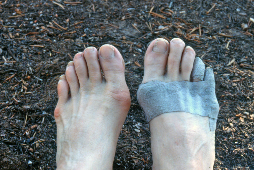 The best preventative I've
found by far is breathable first aid tape. Put it on hot spots before
something more serious starts. Johnson&Johnson makes 1/2 in and 3/4 in cloth
tape, but best product we found is Hartmann Omnifix in 2 inch by 10yd rolls
- enough to wrap entire ball of foot. Google for medco omnifix for the only
U.S. source I've found. Once you get a blister, Spenco 2nd Skin dressing
works, but it is bulky to carry, hard to find, and you may need a lot.
2003 Update - on grueling 8 day trip, got blister with new boots, used
Compeed to cover blister. Worked well. The Johnson & Johnson product sold
in US but licensed from Compeed is not the same as the original. Susan got
hot spot on ankle, used Spyroflex Skinsaver - no more problems. Better
not to get blisters - use preventative measures, socks off every stop, soak
in cold streams every chance, lots of tape. There are many ideas on foot
fixing - all in John Vonhof's Fixing Your Feet which we got before doing the
Camino. John's new edition (7th) is out and you can order from Amazon
The best preventative I've
found by far is breathable first aid tape. Put it on hot spots before
something more serious starts. Johnson&Johnson makes 1/2 in and 3/4 in cloth
tape, but best product we found is Hartmann Omnifix in 2 inch by 10yd rolls
- enough to wrap entire ball of foot. Google for medco omnifix for the only
U.S. source I've found. Once you get a blister, Spenco 2nd Skin dressing
works, but it is bulky to carry, hard to find, and you may need a lot.
2003 Update - on grueling 8 day trip, got blister with new boots, used
Compeed to cover blister. Worked well. The Johnson & Johnson product sold
in US but licensed from Compeed is not the same as the original. Susan got
hot spot on ankle, used Spyroflex Skinsaver - no more problems. Better
not to get blisters - use preventative measures, socks off every stop, soak
in cold streams every chance, lots of tape. There are many ideas on foot
fixing - all in John Vonhof's Fixing Your Feet which we got before doing the
Camino. John's new edition (7th) is out and you can order from Amazon
![]()
However, a French pilgrim who had already walked hundreds of miles, told
us about taping, when she saw Susan's feet, and it worked.
Kenesio Tex tape - 1 inch and 2 inch widths. We just learned about this
stretchy breathable tape from
John
Vonhof's newsletter, and ordered some from KMS. It is similar to Omnifix above,
though we find it doesn't stick to skin as well - sticks to itself just fine.
Footwear Life:
My experience with
Asics Gel Nimbus is that after about 500 miles they have lost most of
their cushioning. My feet are fairly tough by then, so I still get another
couple of hundred miles. At 700 miles they are showing various signs of
physical failure - cracking in various spots, sometimes some delamination of
rubber from fabric, etc.
My current footwear is
Altra Lone Peak. The wear experience is about the same, except I still have my 1st pair that I wear at all times except for a big trip. They must have about 1000 miles and no holes yet.
Gear:
Weight is critical. See our gear page for packs, footwear, etc., see our John Muir page for detailed equipment list for JMT/PCT. Most thru-hikers use alcohol stoves, packs in the 1 to 2 lb range, low topped well ventilated running shoes for the desert. For couples a canister stove is more efficient.
Crampons
If you use running shoes and have to travel over a lot of ice, screw shoes are a poor man's crampons. runwenatchee.com/blogs/blog/screw-shoes-for-winter-running/ tells you how to put screws in your running shoes.
Some PCT hikers use instep crampons, others have found the
Kahtoola Microspikes From REI
to work better. We
finished the PCT in 2010, doing Washington in Aug - Sept. Just had
our trail runners.. There were a couple of snowfields where we would
have used crampons if we had them. For those conditions, I don't
think the microspikes would have had enough bite.
Kahtoola also makes a crampon that fits on trailrunners.
Ice Axe Self Arrest
If you can, attend one of Ned Tibbet's excellent classes. If you can't, at least watch this excellent video on self arrest: Youtube - Self Arrest
Bear Canisters
They are required in most of the Sierras. Yes, you may get away without getting caught, either by a bear or a ranger, but chances are that a bear is going to get your food, and eventually get shot due to people not using canisters. More info on canisters on our gear page. https://www.wild-ideas.net has the largest and lightest/meal hard sided container. They have special rental rates for PCT, JMT, etc. Call them for details: wild-ideas.net/rent/ . We carry a couple of soft Ursacks for all areas of the PCT except the JMT part. The Ursack keeps mice, etc out, as well as less educated bears.
Re Resupply Boxes and Fuel:
It's best to buy at resupply point. Fuels can't be flown. US Postal Service will allow butane/propane canisters and alcohol less than one liter to be mailed ground only provided they are packed and labeled properly. Labeling has changed (2021) ORM-D doesn't work. Need a special limited quantity square on point Hazmat label.
Details if mailing fuel
Always label as ground only, and tell postal clerk ground only.
following is per Steve Herr, JMT-groups.io (with permission)
Governed by USPS Publication 52
section 342.4(b) of the manual
says
b. For surface transportation, parcels must be plainly and durably marked
on the address side with an approved DOT Limited Quantity marking
(see 325.4). Surface shipments bearing the Limited Quantity ground
marking are not required to include the proper shipping name and
identification number. A shipper’s declaration for dangerous goods is
not required for mailable gases sent via surface transportation.
Section 325.4 after you go through most of the legalistic gobbledygook that applies to air shipments
(which flammable gas cartridges do not qualify for) it says:
f. For surface transportation, a Limited Quantity ground mark (square-on-
point) is not required to include the proper shipping name and
identification number.
from Amazon
The square on point limited quantity mark is shown in 325.4(f) as a square, one corner ("point") down, with the top and bottom points filled in with black. For what we're doing, you do not need the name of the commodity, the UN number, or anything else in that square on point mark.
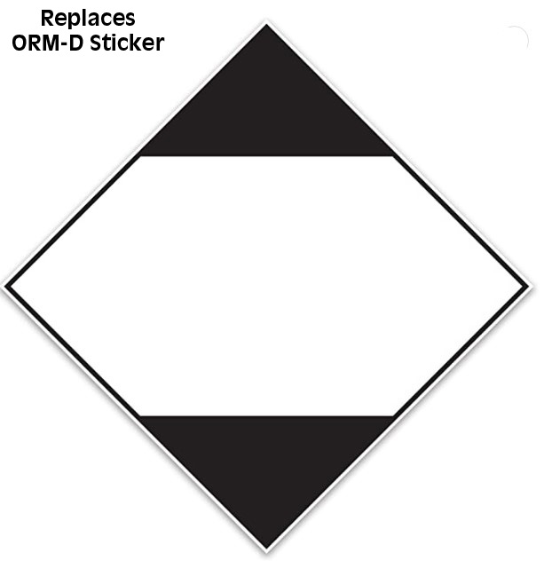
Ralph's note: Alcohol is a flammable liquid and has separate packaging requirements. Briefly, less than a quart, metal screwtop container, enough padding to absorb entire contents if a leak. See
Appendix C section 3A of pub 52 Same limited quantity labeling is required.
I mailed an unopened can of
alcohol to Mt. Laguna for our section A hike, properly packed - wrapped with
paper towels inside a ziplock inside a well padded box. Good thing I
followed the rules because it did leak - not a lot, but all the paper towels
were damp - nothing into outer box.
Food and Lodging Info
You should have Yogi's handbook https://www.pcthandbook.com/ , but also take a look at David P.s page on food and lodging: http://www.emeraldlake.com/pctguide/pctintro.html
Tips on keeping warm:
One of the challenges of the pct is dealing with the extremes of weather. You are going to have some very cold, cold/wet nights by the time you reach Canada. Review http://www.chiff.com/a/camping-sleep-warm.htm
San Diego area help:
The thetrek.co site has a good getting to the southern border page: thetrek.co/pacific-crest-trail/get-pct-southern-terminus/.
ADZPCTKO - Annual Day Zero Pacific Crest Trail Kickoff - what it was
This event is permanently cancelled due to hiker volume.
The bunching of the herd of hikers caused by this severely impacted hiker towns up the trail. It was usually the 3rd week in April.
A similar event - The annual Trail Days Festival happens at Cascade Locks, Oregon about mid August pctdays.com
Kennedy Meadows General Store address change as of 2008:
Kennedy Meadows General Store
96740 Beach Meadow RD
Inyokern, CA 93527
Shuttle Hint for PCT section hikers:
When we did section A we parked in Warner Springs and a
trail angel drove us to Campo. When we did section B, our trail angel was
hiking, so we parked in Warner Springs in the school's little outer lot, and
when we reached interstate 10, called Enterprise Rentacar in Palm Springs.
The PCT comes out at Tamerack Road, which is in their pickup range. They
will drive up to about 12 miles to pickup someone who wants to rent a car.
They will also drive you back after the rental.
Another good source of shuttle info, shower locations, etc that is kept
current:
climber.org/data/index.html
For a Mojave shuttle, the Days Inn no longer gives shuttles. Cell is good
at Cameron Rd, not at Oak Creek. Tehachapi Taxi:
661-600-2771 or California City Yellow Cab 760-338-3494. Verify numbers ahead
of time, as numbers and businesses change.
There is a Mojave Tehachapi regional shuttle that can drop or pickup at
highway 58 trail head cameron exit. See Kern County Transit Route 100 schedule kerntransit.org/routes/route-100 You must call the bus dispatcher first to tell the driver
to detour and stop.
In the Walker Pass area (SR-178) we have these untested numbers, and know
there is no Verizon cell reception. Maybe Att ok. Ridgecrest Taxis, (760) 384-2227 rndtransitco@gmail.com,
Enterprise Car 760-384-2816, Avis 760-446-5556, Dollar 760-446-4554 and other car rentals. You would have
to hitch east into InyoKern or Ridgecrest to get the car rentals. Enterprise
will drive up to 10 miles to pick you up.
An East Side Sierra Shuttle Service that is run by Paul Fretheim started in 2012. https://www.eastsidesierrashuttle.com/ It covers the east side from Yosemite to Death Valley, and will do custom trips to almost any location in the Sierras.
There is a west side shuttle service into Sequoia-Kings Canyon Nat'l Park
from Visalia:
sequoiashuttle.com/
There is a west side shuttle service into Vermillion Valley Resort from
Fresno
vvr.place/hikers/#transportation
Summary of Public Transit to Yosemite:
There was a post on Backpacking Light from John, who lives in
Yosemite valley. He uses public transit on a regular basis. To get to
Yosemite from the east coast, fly into San Francisco or Oakland than take
Bay Area Rapid Transit (BART) to Richmond, there transfer to Amtrak, take it
to Merced. At Merced, take the Yosemite Area Regional Transit bus yarts.com to
Yosemite valley. Coming back from Whitney Portal, there is regional
transit bus service on highway 395. Take it to Mammoth Lakes then YARTS back
to Yosemite valley. (ed. note: if you do
this be cautious at Richmond Bart. It is in a dangerous neighborhood. Don't
walk around.)
For Public Transportation schedules: To get to the Eastern
Sierra or Yosemite, The Eastern Sierra Transit Authority:
estransit.com/routes-schedule/
The important long distance forums:
I monitor the Yahoo BackpackingLight forum, as well as Facebook Group - Pacific Crest Trail>. Backpacking Light is useful but not free - a lot of good comments on gear. If you are planning to thru-hike or section hike one of the others, join the appropriate facebook group.
Trail Journals:
It can be very helpful to read daily journals of
thru-hikers. To get a sampling of these:
www.trailjournals.com an excellent place to follow current thru-hiker journals on
the PCT as well as all the other major trails.
www.postholer.com as of 2008 has
added journaling capability with good features.
PCT Fire Info:
We have a separate page on this: Backpack45 Trail Pacific Crest Trail Fire Info Sources
U.S. Forest Service PCT site - good info: https://www.fs.fed.us/pct/
Current Snow Conditions:
postholer.com/cgi-bin/postHoler a good graphical representation of how much and where.
Temperature Change with Elevation:
If you carry a thermometer, it is sometimes useful to estimate expected temperatures at higher elevations. There is a normal temperature drop of 3.6° F for each 1000 feet increase in elevation. i.e. if you are at 10,000 feet, the temperature is 40° F and it is raining, expect snow at 13,000 feet.
Wind Speed Estimating:
You expect a range of weather on the pct, from snow to triple digit temperatures. What some people do not expect is the possibility of winds that you can knock you off your feet in the desert sections of southern California. See outdoors.org/resources/amc-outdoors/conservation-and-climate/how-to-estimate-wind-speed/ to estimate wind speed. A summary is that 40 mph takes concentration to walk, above 70, almost impossible to walk.
Ice Axe Tether: To see how the strap should be attached to your ice axe, go to climber.org/gear/IceAxeStraps.html
PCT Fire Information Sources:
We have a separate page on this but in brief:
For any fire in the U.S.
inciweb.nwcg.gov for a fire is managed by California Dept of Forestry you can get current info
from
fire.ca.gov/incidents
Cell Phone Coverage
Halfmile has a page with cell phone info by carrier - I
highly recommend looking at it
https://www.pctmap.net/cell/
Satellite Phone:
If you have to have more reliable service than a cell phone, what I personally use is the Garmin Inreach Mini That gives me the ability to send texts via satellite and battery life is good. If you want voice and can afford it and the weight, choose an Inmarsat or Irridium sat phone, https://www.amazon.com/dp/B01H3YUXAM/ref=nosim?tag=wwwbackpack4c-20" rel="nofollow">for example
USB Solar Charger: The Suntactics chargers have gotten some good reviews on Amazon for charging iPods, Pads, Phones and similar devices. The chargers do not have a built in battery. They need to be connected to your device. Charger in direct sun, but device should be shaded. Devices don't charge well if they are hot.
Cameras:
This is constantly evolving for us. We used some of
the Canon Digital Elph series as they were small, light and reliable. They do
not do as well in low light situations with no flash as some other brands,
but otherwise we were happy with them.
My current camera is a
LG G7 smart phone. The image quality is excellent. The only problem is keeping it charged. Staying on airplane mode
all day helps, but for the backcountry, I carry an Anker battery backup
Susan an iPhone, but carries a dlsr: Olympus OM-D
Triple Crown Talk (PCT, CDT, AT) by the Powers:
Saw an excellent presentation (Dec. 2003) at Sunrise Mountain Sports in Livermore by Ken & Marcia Powers on their triple crown trips. They are one of the few couples to complete the triple crown (Pacific Crest Trail, Continental Divide Trail, Appalachian Trail). The show was excellent - good visuals and enthusiastic team presenters - both up front and giving a coordinated talk. They started with the Pacific Crest Trail, northbound, then did the Continental Divide Trail, northbound, and finally the Appalachian Trail, northbound. I've checked out their website www.gottawalk.com . It has an excellent equipment list, item by item and ounce by ounce for each person for each trail. Also a detailed food list. This is an excellent resource and anyone planning to thru-hike any of these trails should look at their website. Since their talk they have thru-hiked the American Discovery Trail as well. Since then, they have walked the Arizona Trail, and a substantial part of the PCT again. Follow them on: https://trailjournals.com/GottaWalk/
Pacific Crest Trail Talk: by Matt Geis
We went to our local
REI and heard Matt Geis talk and show
slides of his 2002 Pacific Crest Trail trip . If you ever get a chance to hear him, do so.
There are now water caches in the desert part of the PCT, where
PCT supporters put out gallon bottles of water for PCT
thru-hikers. He did hit a spot, where all containers
were dry, and he had to hike out to the nearest town to get water. The
convention on these caches is that you do not depend upon them. Carry enough
water to get you to the next guaranteed source. At a cache, drink your fill,
but only take more if essential for safety. When Susan and I did our 2005
section A and B hikes, we would use about two liters from a cache.
Two tips from his talk: Your feet expand. His went up
a size and a half over the course of the trip (back to normal now). He
was using low cut running/walking shoes and went thru I think six pairs
during the trip. Some PCTers bought all their shoes up front, and put
them in their resupply boxes, but were only able to wear the first pair. The
other tip is not to forget you own your equipment. Do not be afraid to
modify it to fit your needs. In his case, some cutting of his shoes
saved a lot of pain, and could have been done days earlier. This is
also something Ray Jardine suggests. Re blisters, foot problems, he had some
the first few weeks due to too many long days and not enough rest days, also
did not take boots and socks off at every break at first - did later. A
third tip - he said it was fairly easy to get sponsors for such things as
shoes.
One of his highlights was the
Vermillion Resort, as was mine on
the John Muir Trail. They make a big thing out of the PCTers and JMTers that come thru.
1st beer and 1st night free.
Muir Trail Ranch is another resupply point slightly farther south of
Vermillion Resort, but they have guests that take priority over walk-ins, so
have a reservation if you want a meal and place to stay.
He talked about the experience of being on the trail,
and being back in the city after finishing the trip. What he said was like a
flashback to me. There is no such thing as post trail depression. What
happens is that you are on this high - you understand the stresses other
people are having with everyday life, but you can't be mad at anyone, its
been weeks or months just thinking about food, shelter and other hikers
along the trail. The feeling gradually wears off, but at the same
time, the memory of the more difficult parts of the trip start to fade, so
you have this great experience to draw on. (There are lot of times on the
trail when you think: Why am I doing this? This is NOT fun, but somehow the
good parts outweigh it.)
PCT Books by category
Classic Books for the PCT
Ray Jardine's Trail Life is a must for anyone thinking about doing the PCT. The 3rd version of his classic lightweight backpacking book. The origin of the ultralight philosophy - updates his 2nd book Beyond Backpacking
![]()
Ray Jardine's Beyond Backpacking - the 2nd version of his classic lightweight backpacking book, and has the essentials, even though Trail Life has additional information.
![]()
Paul Bodnar's Pocket PCT: Complete Data and Town Guide - distances, features, water sources, facilities on the PCT, tied to Halfmile's maps, and Guthook's app - the current replacement for Ben Go's Data Book. Guthook now rebranded to FarOut. Last edition is 2016.
![]()
Ben Go's Pacific Crest Trail Data Book - distances, features, water sources, facilities on the PCT, elevation profiles and resupply stations - Ben is Benedict for author lookup purposes.This book is intended to be used with the two below. This book is somewhat obsolete now, as mileages have changed since 2005, but ties into the Schaffer guides so has some use.
![]()
Jeff Schaffer, Thomas Winnett and others: The Pacific Crest Trail: Southern California Still the only narrative guide, cut out appropriate sections, carry 1st one and rest go in the resupply boxes. Main issue with entire series is that trail has changed some, and landmarks such as "old jeep road" have vanished.
![]()
Jeff Schaffer: The Pacific Crest Trail: Northern California A useful read, cut out appropriate sections, carry 1st one and rest go in the resupply boxes. - published March 2003. A must.
![]()
Jeff Schaffer, Andy Selters The Pacific Crest Trail: Oregon & Washington New edition as of 2004 - Still a useful read for the PCT hiker.
Yogi's PCT Handbook. She has hiked the PCT at least 3 times and has put together a very good 2 part handbook, the large pages to be read ahead of time and small pages to be carried with you. Further detail on water points, resupply, etc. You have to order it from her - see her website www.pcthandbook.com Highly recommended.
Halfmile'smaps and Halfmile's PCT app. Halfmile's free topo maps with trail and trail features marked are now the standard reference. Yogi will print the maps for you at a reasonable cost. See her site. To download your own maps, bo to Halfmile's website www.pctmap.net From the website, you can find how to get the free app. Highly recommended.
Guthook's PCT app - FarOut. This is a very useful app - maps, water, etc. See his website faroutguides.com/ The initial PCT SoCal app is free, and includes everything from Campo to Mt. Laguna. The remaining sections are about $35 for the entire trail. Highly recommended.
![]()
Scott Parks Pacific Crest Trail Pocket Maps - Southern California - This book is primarily about the excellent topo maps in a 6x9 in 1/4 in thick book. In addition it contains mileage data points, elevation profiles, resupply and water points. Use the Amazon Search Inside to check it out. It was originally published in 2011, but in print on demand, so is updated annually. Check the copyright inside the cover for the edition date.
![]()
Scott Parks Pacific Crest Trail Pocket Maps - Northern California - This book is primarily about the excellent topo maps in a 6x9 in 1/4 in thick book. In addition it contains mileage data points, elevation profiles, resupply and water points. Use the Amazon Search Inside to check it out. It was originally published in 2011, but in print on demand, so is updated annually.
![]()
Scott Parks Pacific Crest Trail Pocket Maps - Oregon & Washington - This book is primarily about the excellent topo maps in a 6x9 in 1/4 in thick book. In addition it contains mileage data points, elevation profiles, resupply and water points. Use the Amazon Search Inside to check it out. It was originally published in 2011, but in print on demand, so is updated annually.
Eric the Black's 5 volume PCT Trail Atlas. This is a pocket sized guide with color maps, utm coordinates, camping and water locations. I have used it and prefer the greater detail of the Wilderness Press guides, along with my own maps, but it is a useful choice. Eric has also done a JMT Atlas.
![]()
Leslie Croot's Pacific Crest Trail Town GuideThe guide to the 80+ towns and resupply points along the PCT - getting somewhat dated.
![]()
George and Patricia Semb Day Hikes on the Pacific Crest Trail: California - Good for planning resupply points - lists access points to PCT.
![]()
George and Patricia Semb Day Hikes on the Pacific Crest Trail: Oregon & Washington - Good for planning resupply points - lists access points to PCT.
Relevant to PCT Hikers but not guidebooks
![]()
Deep Survival: Who Lives, Who Dies and Why by Laurence Gonzales. This should be mandatory reading for anyone doing moderate risk activities, let alone thru-hikers, backpackers, mountain climbers, etc. It certainly made me rethink the things we do when backpacking. It makes fascinating reading, but to summarize what I got out of it: Be sure that what you are thinking of as many years of experience, is not really many years of being very lucky.
Sierra Nevada The Range of Light by Aaron Doss. Aaron is a 2006 pct hiker that we crossed paths with for several days. He was constantly taking photos, and now has come out with this absolutely spectacular tabletop photo book. Its pricey and hard to get, but worth it.
![]()
Karen Burger and Daniel Smith's The Pacific Crest Trail: A Hiker's Companion- route descriptions, day hikes, short backpacks, plant & animal info, history. Don't know that I would carry this - maybe read first and cut out what I wanted.
![]()
Jon Vonhof Fixing Your Feet is the last word on foot care. He treats feet on ultra marathons and will give you more than you ever wanted to know on treating blisters and foot problems.
![]()
Elizabeth Horn - Sierra Nevada Wildflowers . Descriptions and color photos of many of the wild flowers you will see in the Sierras.
Leonard Daughenbaugh - Sierra Crest Route. You know of the JMT, and probably Steve Roper's High Route. This book describes a route closer yet to the Sierra Crest, entirely off trail, no more than a mile off the crest, and usually within a half mile of the crest. Almost all text, most in description of mountaineering opportunities from the route, so I expect that this will become a mountaineer's bible.
Personal Accounts
![]()
Cheryl Strayed - Wild: From Lost to Found on the Pacific Crest Trail. A very popular personal account - good story of Cheryl's life experience. Quite a bit more in it than just the pct experience.
![]()
Ray Echols - A Thru-Hiker's Heart - Tales of the Pacific Crest Trail. I love reading PCT accounts, and this is no exception, but there are very few that I would recommend to my non-hiking friends. This is one of those. It is more like reading Edward Abbey than a hiker's story.
![]()
Barbara Egbert - Zero Days: The Real-Life Adventure of Captain Bligh, Nellie Bly and 10-year- old Scrambler on the Pacific Crest Trail - We met Scrambler and her family at the kickoff, and enjoyed reading this tale of her adventure by her journalist mother.
![]()
Since Matt's talk, Angela & Duffy Ballard wrote A Blistered Kind of Love. This an entertaining adventure read, not a how to, though it gives you a good feel for what is needed. Read it before you go, particularly if you are a couple.
![]()
Dan White - The Cactus Eaters, How I Lost My Mind - And Almost Found Myself - On The Pacific Crest Trail. This lighthearted account, got a lot more prestigious reviews than anything else I've seen on the PCT, and I was a little biased against it, thinking the book professionals were attempting to anoint a new Bill Bryson. I did enjoy it in spite of my attitude. It's a little a la Bryson, but that's a good thing. I actually like Bill Bryson. Also, Dan's walk was a few years back, so I found it interesting comparing the differences over just a few years
![]()
Diane Soini - Piper's Flight: A solo woman's journal on the Pacific Crest Trail. I haven't read Piper's account, but she is a respected member of the trail community and I am sure what she has to say is of value.
Diane Soini - Adventure and Magic. This is Diane's ebook of her journal on the PCT. Available from Lulu.
![]()
Another one Matt Geis mentioned is Soul Sweat & Survival on the Pacific Crest Trail by Bob Holtel. This is someone who did a solo run over the PCT in the course of three summers.
![]()
Eleanor Guilford - One Hundred Mile Summers: Hiking the Pacific Coast Trail from Mexico to Canada Eleanor is the oldest woman I know to have completed the pct (in 1989 at age of 71). Now (2008) at age of 91 she is giving REI talks on the pct. When Eleanor did the PCT, there were fewer thru-hikers, and a lot more temporary sections. Just reading about trail conditions 18 years ago, will keep your attention.
![]()
George Spearing: Dances With Marmots, A Pacific Crest Trail Adventure - available in paperback or download. A lot of people have enjoyed this. Check out all the reviews in Amazon.
Pacific Coast Trailway was compiled by Clinton C Clark in 1945. This classic was recently scanned by Daniel Craig Giffen and is available for online viewing at pcttrailway.pctplanner.com
Not directly related, but of interest to PCT hikers:
![]()
Elias Butler and Tom Myers - Grand Obsession, Harvey Butchart and the Exploration of Grand Canyon. Butchart was the first person to thoroughly explore the Grand Canyon on foot, and the first person to walk the length of the park below the rim. His tips were what enabled Colin Fletcher to walk it in one season. Also a story of hiking obsession, a story known to all long distance hikers. In Nov 2008, this book won a National Outdoor Book Award in the History/Biography category.
![]()
The Man Who Walked Through Time by Colin Fletcher: The classic story of Fletcher's walk through the Grand Canyon.
![]()
Lawton "Disco" Grinter - I Hike an entertaining collection of trail stories, mostly true by this Triple Crown hiker. Think Bill Bryson.
![]()
Unseen Hazards That Threaten Hunters, Campers and Hikers - Jerry Genesio. i.e. bacteria that can kill you while hiking in US. Haven't read it, but plan to.
![]()
Gifts from the Mountain, Simple Truths for Life's Complexities by Eileen McDargh. Watercolors and wisdom drawn from backpacking inspiration. Not just PCT. Hard to classify, but I highly recommend it.
Peter Potterfield - Classic Hikes of the World. A gorgeous book full of tempting hikes if the PCT experience has infected you. Does not include the PCT but has the JMT.
![]()
Last Child in the Woods: Saving Our Children from Nature-Deficit Disorder by Richard Louv. Not on JMT, but a strong case for getting children out into the wilderness.
![]()
Spark Your Dream by Candelaria & Herman Zapp Not a PCT hiker story, or even a walker's story, but an incredible long distance adventure. Cande is from Argentina. They drove their 1928 Graham-Paige sedan from Argentina to Prudhoe Bay, Alaska, having a child in the process. We met this couple and their car while they were selling their book outside of a local harvest festival in 2008. Still a young couple, they now have three children, are expecting their fourth, and are planning to drive their car across Asia.
![]()
Three Hundred Zeroes by Dennis Blanchard. For those PCTers who are considering the Appalachian Trail, this personal account gives you a good feel for what to expect.
DVD/VHS on a PCT thru-hike
![]()
Tell it on the Mountain - Tales from the Pacific Crest Trail A full length theatre quality documentary, following six thru hikers along the entire PCT. Well worth seeing, even if you are not a thru hiker.
Walking the West. A documentary of two people who walk the PCT - won Best Documentary at the California Independent Film Festival, also played at Ashland Film Festival. A realistic account of the trials and tribulations of thru-hiking the PCT. You can only buy it through the Pacific Crest Trail Association website, but the filmmakers website www.walkingthewest.com> has buy buttons that go directly to the PCT association site.
PCT 2005 DVD by Whistler & H of 2005 hikers Another great free DVD, similar to Weathercarrot's - mostly just music and images, but kept me enthralled. Some great high sierra snow images.
WeatherCarrot's DVD of 2004 PCT hikers. This is a truly inspirational DVD - just images and music, the images contributed by some 70 2004 hikers. It was shown at the 2005 kickoff and is being distributed free if you can find a copy. To me, it represents all the good parts of a PCT thru hike. Look at some of the following DVDs to get a more complete picture of a thru hike.
![]()
Walk by Scott Herriott - a 2003 DVD documentary on Pacific Crest Trail thru-hikers, The off the wall approach to telling this story quickly got me involved. There are a number of video clips of segments of the trail, but the focus is on where the hikers gather as they encounter the outside world - the kickoff meeting, Kennedy Meadows, VVR, the pancake place and others. Most of the time you are hearing them talk to each other about hiking, feet, whatever. They have just hit a high point on the trail so are upbeat and very animated. Maybe not truly representative of the average mood of a thru-hiker, but it makes a fascinating story. Any long distance hiker is going to enjoy this video. Potential thru-hikers and curious non hikers are going to be caught up by the enthusiasm. It can be ordered thru Amazon or directly from www.walkpct.com
![]()
Still Walking - by Scott Herriott - 2005 sequel to Walk. Food for the hiker's soul. This sequel even exceeds the original, and covers the 2005 PCT hiking season. I highly recommend it. Order from Amazon or directly from www.walkpct.com .
![]()
Even More Walking - by Scott Herriott - 2006 continuation of Scott's PCT walking series. After viewing the first two of the series, I eagerly looked forward to this one. I was not disappointed. If you have thru-hiked or section hiked during these years, you will see familiar faces, and if considering the PCT, you will get a good flavor of it. On Amazon, or directly from www.walkpct.com .
![]()
Walked - by Scott Herriott aka Squatch - 2007, 2008 continuation. Not to be missed if you are a PCT hiker. Get it from www.walkpct.com .
RESOULED on the Pacific Crest Trailby John Oldford - a DVD documentary on a 2002 thru-hike. There was a good comment about it in the Backpacking Light forum and it was shown at the 2004 PCT kickoff. I just recently got a chance to see it (Sept. 2004). I loved this DVD. A very professional looking film and definitely worth seeing and adding to your video library. I especially liked the 3-D maps with the trail overlaid on them - made it easier to track their progress. John Oldford started alone on 4/26 with his video camera but for the most part traveled with several others. Good balance between trail footage and hiker conversations. Some spectacular shots of the Pacific NW snow caps. A great shot of the trail zig zagging along in Northern Washington on what looks like a knife edged crest. I enjoyed the camp shots showing cooking, the gear, etc. Lame hiker jokes made me smile - hint: banana first aid.
Ryan's PCT Class DVDs available for free downloading for 2003 thru 2007: Click on https://www.whiteblaze.net/forum/showthread.php?t=30207 for details.
Dinsmores River Haven 2008 YouTube Video: Class of 2008, or anyone who has been to
Dinsmores check this out
Click on https://www.youtube.com/user/zaqueltooocool
Also, for 2009 season, they have moved, so check their
website:
https://www.skykomish-show-n-shine.com/GenWebPage.ihtml?formid=39
DVD on Sequoia-Kings Canyon backcountry experiences. This is slightly off topic from PCT DVDs, but relevant. Bob Kenan was a backcountry ranger in Sequoia-Kings Canyon National Park for 30 years. He has put together a DVD of his experiences, including interviews with other backcountry rangers, and some 50 interviews with backpackers and PCT thru-hikers. I haven't seen it, but sounds good. Order from his site at https://www.messagefromthemountains.net
Pacific Crest Trail Records and attempts
I've collected these from various places. Please email me if you have corrections, new candidates, etc. at rbalcorn at gmail dot com.
Fastest Assisted Record:
Definition: Assisted means crew following hiker and providing food & shelter at every opportunity. Hiker just has to walk the PCT. Feet on the ground the entire way.
2023 Karel Sabbe 46 days, 12 hours, 50 min, entering Canada on August 26. https://www.sfchronicle.com/outdoors/article/ultrarunner-smashed-pacific-crest-trail-speed-18299645.php
2021 Timothy Olsen (*not feet on the ground*) 51 days, 16 hours, 55 minutes. Hit Canadian border on July 22nd. Because of fire closing part of the PCT, Timothy had to be driven to where the trail resumed. In the course of the detour, he ran 20 miles, which was the length of the closed trail segment. sfchronicle.com/travel/article/Ultrarunner-sets-speed-record-on-Pacific-Crest-16335467.php
2016 Karel Sabbe 52 days, 8 hours, 25 min, entering Canada on August 13th. facebook.com/Karel-Sabbe-Ultrarunning-1693493784271108
2014 Joe McConaughy - 53 days 6 hours 37 minutes, crossing the Canadian border on August 10th.nwpr.org/post/seattle-runner-smashes-speed-record-full-length-pacific-crest-trail
2013 Josh Garrett - 59 days 8 hours 59 minutes, left southern border June 10th. This was two days after Anish who got the unsupported record a day earlier (see below). pcta.org/2013/pct-speed-record-is-shattered-twice-13750
2005 David Horton - 67 days - June 4 to Aug
9 at age 55
https://sturminator.blogspot.com/2005/08/full-friday-bag-o-blog.html
https://www.backpack45.com/newsletter2005.html (Sept
newsletter)
Fastest Unassisted:
Definition: Unassisted means normal PCT hiker, no slack packing.
2023 Sept 18, Jessica Pekari Fastest female unassisted: 63 days, 7 hours, and 31 minutes traveling North to South
fastestknowntime.com/fkt/jessica-pekari-pacific-crest-trail-ca-or-wa-2023-09-18
2023 Sept 6, Nick Fowler 52 days, 96 hours, and 18 minutes traveling North to South
sfchronicle.com/outdoors/article/pacific-crest-trail-hiker-18359949.php
2022 August 7, at 8:56 P.M., Josh Perry 55 days, 16 hours, and 54 minutes
outsideonline.com/outdoor-adventure/hiking-and-backpacking/pacific-crest-trail-fkt-josh-perry
2013 Heather "Anish" Anderson 60 days and 17 hours and 12 minutes, started June 8th from southern border. pcta.org/2013/pct-speed-record-is-shattered-twice-13750
2013, July 7 in progress per email from Marcia Powers:
Triple Crown hiker Anish, Heather Jo Anderson, is currently past the 1000 mile mark on the PCT. She is on track for the fastest known time, FKT, by hiking 41 miles per day. She is entirely self supported to the extent of walking to resupply points rather than hitching.
2011 Scott Williamson completed on 11 Oct 2011 64 days, 11
hours.
https://mailman.backcountry.net/pipermail/pct-l/2011-October/054732.html
2009
In Progress - Scott Williamson and Adam Bradley attempting to break
Scott's
unassisted record, at the same time breaking David Horton's
assisted record time. Link to Jacob
Nahin's video interview with Scott Williamson and Adam Bradley
at Agua Dulce. See fastest California below.
Adam & Scott arrived at the Oregon/Washington
border on July 31st, 53 days, 8 hours, 41 minutes, 57 seconds
after departing from the southern terminus, and 10 days 14
hours 16 minutes 12 seconds after entering Oregon. https://www.trailjournals.com/entry.cfm?trailname=9275 (author's note: Susan and I just went thru the section about
20-25 miles north of Cascade Locks, and saw Scott's signature
on a pair of faded blue levis, dated 8/1/09 along with dozens
of other signatures from 08 and 09.)
8/12/09 new record - Scott & Adam - 65 days 9 hours 58
min 47 seconds.
71 days 2 hours in 2008 - finished Aug 18 - Scott Williamson &
Tattoo Joe (Joe Kisner)
https://mailman.backcountry.net/pipermail/pct-l/2008-August/019696.html
https://www.sierrasun.com/article/20081124/NEWS/811249978/
https://team.inov-8.us/2009/02/scott-williamson.html
a little controversy in that they went thru an active fire
area (Clover Fire) that was closed to pct hikers,
however, they did get permission from the firefighters and
rangers on the spot.
79 days 21 hrs in 2007 - finished Aug 7 -
Tattoo Joe https://mailman.backcountry.net/pipermail/pct-l/2007-August/009353.html
81 days 8.5 hrs in 2005 by Squeaky (Mat Hazley) http://www.trailforums.com/detail.cfm?PostNum=5674
83 days set in 2003 by Ray Greenlaw https://www.backcountry.net/arch/pct/0308/msg00119.html
85 days in 2001 by Brian Robinson as part of his 2001 triple
crown. www.outdoornewswire.com
Catra - dirt diva - attempted fastest unassisted
(2007).
https://catrapct.blogspot.com/2007/07/days-67-68-sun-mon-july-29-30.html
had to abandon attempt in Sisters after Giardia & injured knee
74 days in 2002 - RocketGirl - (Terry Wiemer?) (pct 02, cdt
04)
https://www.backcountry.net/arch/pct/0311/msg00244.html
https://friends.backcountry.net/pipermail/pct-l/2007-May/007827.html
http://www.trailforums.com/detail.cfm?entryID=35868
Someone said RocketGirl is a madeup hiker. Yogi's journal
entries indicate she knew Rocketgirl, Yogi confirmed
this to me by email.
Fastest California section
Adam Bradley and Scott
Williamson - 7/21/2009 - 42 days, 18 hours,
https://www.trailjournals.com/entry.cfm?id=284061
unsupported (this includes no riding in cars, as well
as no pre-arranged rendezvous with personal food deliveries,
etc. - just utilizing the available services and mail drops,
on foot.)
Andrew Skurka - 45 days - 2006 https://www.andrewskurka.com/PCT06/index.php
Fastest Oregon section
Adam Bradley and Scott Williamson - Adam & Scott arrived at the Oregon/Washington border on July 31st, 10 days 14 hours 16 minutes 12 seconds after entering Oregon. https://www.trailjournals.com/entry.cfm?trailname=9275
First Winter Southbound PCT
In Progress Jan 2015 - Shawn Forry and Justin Lichter
pcta.org/2015/meet-two-guys-winter-thru-hiking-pct-19-incredible-photos-26687
Feb 2015 - through the Sierras to Walker Pass
justinlichter.com/blog
ladyonarock.com/2015/02/11/video-interview-pepper-and-trauma-winter-pct-thru-hike/
Finished on March 1, 2015
rgj.com/story/life/outdoors/recreation/2015/03/01/pacific-crest-trail-winter-hike/24232641/
facebook.com/hashtag/pacificcresttrail?source=feed_text&story_id=10153320754187985
First Yo-Yo (round trip)
Nov 2014 Raindance Started Apr 25, completed Nov 5th, 195 days
per April Sylva post in Facebook Pacific Crest Trail Group and
postholer.com/journal/viewJournal.php?sid=982f939427e37b6aae767cdb1ffbe19f&entry_id=44744
Nov 2004 - Scott Williamson - 197
days, and in Nov 2006 - 191 days https://www.backpacker.com/article/8846
Most Completions:
Scott Williamson - Completed 11th PCT in 2008
First person to complete PCT in single season on horseback
Jim McCrae of Aldergrove, BC - 1988. Per email from Tamara Hamilton "He had two horses and one mule in 1988. One of his horses was injured in Washington and had to be trailered home, but he completed the remainder of the journey with Shiloh (a grade buckskin gelding) and Duke ( a very temperamental mule). Jim shoveled a path through the High Sierras, as that year the trail was not melted when he went through. Previous horse packers had taken alternate, lower, routes. Jim stuck to the crest."
Altergrove Star - Backcountry Horsemen of B.C.
infocus magazine 2009
Other attempts:
I'm not sure if she actually made it, but was past Harts Pass in deep snow on Oct 3, 2013. "midnight rider" Alina Dudding, her horse Valentino. Thanks Donna Sauffley for the info. midnightridernvalentino.tumblr.com/
Oldest man to complete the PCT
Age 81 2018 Al Learned - started May 15 age 80, finished Sept 28 age 81. Al was already a Triple Crowner, having done the PCT earlier in 2003.
m.facebook.com/notes/al-learned-hikes/our-story/1669280853096149/
Age 75 Calvin Batchelder Per email from Meadow Ed: "Back in 96
my friend Calvin (Batch) did from Mex to Sierra City. In 97 he
came back out to redo the trail and actually rewalked up to
Kersarge Pass then jumped to Sierra City and made it to
Canada. He was 75!" also in Walking the West dvd
documentary.
Age 78 Per pct-l post from Jim (Bigfoot) & MIna : "John Olley
aka JohnnyO, from Dunsmuir, who is 92 finished section hiking
the Pct in the early 90's and finished the AT in 1994. John
was the volunteer trail maintainer at Castle Crags state park
for about 15 yrs, quitting at 90 yrs old."
https://mailman.backcountry.net/pipermail/pct-l/2007-August/009583.html (My estimate for age is completed in 93, age 92 in 2007 makes
him 78 in 1993)
Age 80 Bob Holtel ran the pct again in 2010
obituaries.tbrnews.com/us/obituaries/tbrnews/name/bob-holtel-obituary?id=6693074
Oldest woman to complete the PCT
80? "Listener" in progress in 2012 - no word on finishing
Mary (Medicare Pastor) Davidson - 2012 age 70 and 50.5 weeks finished July 24, 2012 per personal communication
"TOB" Tough Old Broad (Jane D.) 2006 age 70 mailman.backcountry.net/pipermail/pct-l/2006-July/000391.html Also, personal communication
Eleanor Guilford in 1989 at age of 71 https://redwood.sierraclub.org/articles/October_05/EnvironmentalForum_Nov.html
Oldest combined couple age to complete the PCT
147 years 9 months combined age: Jonathan Upchurch and Betty Upchurch had a combined age of 147 years, 9 months when they completed the PCT as Section hikers. Finished October 12, 2024.
143 combined age: Ralph and Susan Alcorn (timecheck and backpack45), 74 and 69. Finished Sept 7, 2010, 11:10 am.
Oldest man to thru-hike the PCT
Age 81 2018 Al Learned - started May 15 age 80, finished Sept 28 age 81. Al was already a Triple Crowner, having done the PCT earlier in 2003. m.facebook.com/notes/al-learned-hikes/our-story/1669280853096149/Billy Goat (George Woodard) is the current
contender. He has hiked the PCT at least 6 times. In 2008 he
was age 69 and on the trail. I assume he finished, but no
confirmation.
https://articles.latimes.com/2008/jun/25/local/me-billygoat25
I think there have been some 70+ and maybe 80+ who thru-hiked it, but no
documentation.
Longest number of years to complete hiking the PCT
37 years 3 months - Jonathan Upchurch and Betty Upchurch took
37 years, 3 months to complete the PCT as Section hikers – from July 17, 1987 to October 12, 2024
Mary Kwart aka Fireweed, 34 years.
Started in 1976, finished 9/14/10 at age 58.
Per email from Meadow Ed: "I ran into a feller
up to Stehikin back in 01 who was doing it on horse back,
Ralph Looney! It took him 49 years to complete it! I asked him
why he did not wait til 02 and make it 50 years! His answer
was Hell at my age i felt i should do it now , who knows what
another year will bring."
Jim Batdorff - 26 years - started in 1981 and completed in August 2007 at age 65
https://mailman.backcountry.net/pipermail/pct-l/2007-August/009567.html
in progress:
expected 29 years per pct-l email from barney rubble: " Keith who is known
as St Alfonzo, started section hiking in 1980. He has
completed everything north to Cascade Locks. He plans on doing
1/2 of Washington in 08, and the other 1/2 in 09. I have seen
him on the trail the last few years."
https://mailman.backcountry.net/pipermail/pct-l/2007-August/009585.html
expected 44 years per pct-l email from Steel-Eye: "I began
hiking the OregonSkyline Trail in late July or early August of
1965, several years before it was incorporated with other
trails in California and Washington to form the PCT, and have
hiked portions of the PCT most years since. Substantial
portions were: Oregon thru-hike in '99, Cascade Locks to
Stevens Pass in '00, Stevens Pass to Manning in '02, and Campo
to Sierra City in '07. About 480 miles remain, but I'm only 65
so I should complete it in '08"
https://mailman.backcountry.net/pipermail/pct-l/2007-August/009586.html
Oldest man section hiking
Chuck Ward (aka "Catalina Chuck") - 73 in Dec
2008 - A, C, F, G and part of H in 2008
- 74 in Dec 2009 - Calif B, D, H, I in 2009, Calif E, J, K, & L in 2010,
in Aug 2011 at age 75 completed Calif M & N
Ralph Alcorn 72 contender - 72 in May 2008 - Agua Dulce to
Cottonwood Pass, Ashland to Shelter Cove in 2008,- 73 in May 2009 - Shelter Cove (OR) to Panther Creek
Campground (WA) in 2009, Completed PCT in Sept 7, 2010.
Oldest woman section hiking
Susan Alcorn 67 in 2008 - Agua Dulce to
Cottonwood Pass, Ashland to Shelter Cove
- 68 in 2009, Shelter Cove to Panther Creek Campground. Completed PCT in
2010.
Oldest woman to have hiked a section of the PCT
80? "Listener" in 2012 seen near Crater Lake
Oldgal (Marge Prothman) 73 in April 2000 Section B , also something in 2005.
Youngest person
2014 Christian BuddyPacker Thomas age 6 completed pct on Nov 24th. buddybackpacker.com
facebook.com/BuddyBackpacker
2012 Monkey ( Sierra Burror ) age 8 when started on April 22nd, 9 when finished Sept 23rd with her mother Mama Bear (Heather Burror) https://www.sierrawave.net/14329/mother-and-daughter-complete/
2011 Sunshine (Reed Gjonnes) age 11. Also, Sunshine hiked the AT in 2012.Sunshine has now thru-hiked the CDT in 2013 at the age of 13 which made her the youngest person to hike the CDT and complete the triple crown. Here's a link to the USA Today article which verifies all 3 of her hikes. usatoday.com/story/news/nation/2013/10/27/young-hiker-triple-crown/3282981/
2007 - Oblivious (Brian McCarty) age 12 - hit Oregon 8/2 - did AT in 05.
Traveling with
father Troll (Bill). Both in kilts. Finished PCT on 9/16/07.
Planning on CDT in 2009.
2004 - Scrambler (Mary Chambers) age 10. Travelling with
Barbara Egbert & Gary Chambers. https://www.backcountry.net/arch/pct/0410/msg00542.html
https://www.sfgate.com/cgi-bin/article.cgi?f=/c/a/2009/05/03/CMQL10MA1H.DTL
1977 - Strider (Greg Hummel) age 11. https://www.backcountry.net/arch/pct/0410/msg00542.html
First Thru-hike:
1952 Martin Papendick - (North to South) https://www.backcountry.net/arch/pct/9807/msg00022.html
1970
Eric Ryback - challenged due to rides accepted. https://www.pcta.org/about_trail/fun.asp
1972
Richard Watson (confirmed) https://www.bookrags.com/wiki/Pacific_Crest_Trail
1972 the group of Bill Goddard Toby Heaton, Butch Ferrand,
Wayne Martin and David Odell. David had done the AT in 71 and
did the CDT in 77. (per 2010 email from David Odell).
Families that have thru-hiked the PCT with more than two children:
2015 nobo The Ravens (trailname). Tim Umstead, Ann and their children Will 13 and Joon 9. Will broke leg last 300 miles so had to complete that section in 2016. They went on to complete the Triple Crown in 2019
theravens15.wordpress.com/about/past-trips
2018 sobo Vince Strawbridge, Monica, and their 4 children - Aiden, June, Henry and Georgiana, ages ranging from 17 to 11. They have since completed the CDT then completed the AT and the Triple Crown on June 21, 2021.
thelakelander.com/strawbridge-family-trek
baynews9.com/fl/tampa/news/2018/11/19/lakeland-family-walks-2-600-miles-from-canadian-border-to-mexico
outsideonline.com/outdoor-adventure/hiking-and-backpacking/strawbridge-family-triple-crown
2019 nobo Adam and Mindi Bennett and their 4 children - Sierra 16, Kaia 14, Tristan 12, Ruby 9. Finished at Canadian border July 18
outsideonline.com/outdoor-adventure/hiking-and-backpacking/family-hikes-pacific-crest-trail
First women to thru-hike:
1972 Mary Carstens - https://www.pcta.org/about_trail/miler_list/
1974 Jean Beck (now Audet) First woman to thru-hike both AT (72) and pct with her husband Rick
https://www.backcountry.net/arch/pct/0412/msg00159.html and
per email 2010 from David Odell 72 thru-hiker
1974 Denise Myers
https://www.backcountry.net/arch/pct/0412/msg00264.html
1976 Teddi Boston - First to thru-hike solo southbound. Hiking north to south,
starting May 1st, Boston completed
the PCT in 1976. At the time, she was in her forties and a
mother of four
https://www.pcta.org/help/join/magazines/kick_off.asp
https://www.backcountry.net/arch/pct/0412/msg00159.html
1976 Carolyn 'Ravensong' Burkhart along with Teddi Boston above, First to thru-hike solo north bound - personal communication
1984
Joanne and Marion (Mugs) Knezacek - (source https://www.library.ubc.ca/archives/pdfs/chronicle/AL_CHRON_1984_2.pdf )
First Person to Run the entire PCT
Bob Holtel over the course of three summers
starting in 1885 at age 55. He did it again, over
two summers, starting in 2010, finishing at age 80. His book
on the first run is listed above.
https://www.bobholtel.com/
https://www.dailybreeze.com/ci_15093127
Lowest REI number held by a PCT hiker.
This just for fun category was inspired by
some recent pct-l messages re REI. I'm not recording the
lowest 3 digits to prevent compromising the number.
Thatcher Koch - 139###.
Susan Virnig - 127### 1967
Paul Freiman (Bivy) - 106###
Yosemite James 74### 1964-65.
Other:
2001 Brian Robinson PCT, AT, CDT all
completed in one calendar year.
https://www.washingtonpost.com/wp-srv/aponline/20011027/aponline213001_001.htm
Ken and Marcia Powers completed the "Grand Slam" - PCT, AT,
CDT, ADT. https://www.discoverytrail.org/news/powers/index.html They
have now (2008) finished the Arizona Trail.
Peter Bakwin's Fastest Known Times page:
fastestknowntime.proboards.com/ - A lot of information on this site on fastest times on many different trails. Check it out.
PCT Early History
The Pacific Crest Trail exists mainly due to the efforts of Clinton Clark and Warren Rogers, starting back in the 1930s. The family of Warren Rogers has gathered the early history together and built a website: http://pct-nst.com/ . It makes for interesting reading.
Our Gear List for PCT or JMT:
The gear list is a google spreadsheet. To get an xls file you can save, click on https://docs.google.com/spreadsheets/d/1NQ9fzrrf7QXF6I5KYDNyC8Sjtammz_Ga9GhxzxBppf0/edit?usp=sharing - on the bottom right of the resulting google spreadsheet is an edit button. Click that, and you will be able to view it in a form that can be saved off to your hard drive as an xls file.
Trail Journals:
To follow some of the current PCT and other thru-hikers,
click on the following to go to www.trailjournals.com ![]()
- also a good place to see detailed gear lists - an example is Ken and
Marsha's American Discovery Trail 2005 journal.
Backpacker Magazine Wisdom of the Week:

Their website www.backpacker.com is an excellent resource - far beyond the normal retail outlet site. Look in the community section and you can find useful forums that I check at least weekly - broken out by topic. Several on regions such as international, northwest, book reports, backpacking with kids, just for women, etc.. The magazine is published by Rodale Press - publisher of Organic Gardening, etc., and has strong environmental roots.
A Training Resource - BLM Lands Near You:
An alliance of conservation organizations has recently put together a site promoting the crown jewels of the BLM system. You can click on the following and find the selected areas by state: https://www.conservationsystem.org/conservationsystem
More Temperature Data than you can ever use:
Six PCT hikers carried data recorders during their 04 and 05 through hikes.
You can look at temperatures for selected days, time of day, etc. Keep in
mind that these recorders may have been in a pack, or exposed to direct sun,
so don't represent average air temperatures. For example, that 126 F day
probably was inside a hot pack pocket.
https://www.michaeljaylissner.com/pct-temperatures
Other Links:
Crow's blog - a huge amount of PCT gear info along with some interesting stories http://asthecrowflies.org/
Do your own gear patterns, lightweight gear, excellent advice on thru-hiking https://thru-hiker.com/materials/index.php
An excellent but huge site dedicated to lightweight backpacking is www.backpacking.net, forums, archives, gear, the works.
Joe Valesco's lightweight gear includes belt bags and shoulder strap bags for carrying cameras, etc. https://www.zpacks.com/
Also, Joe's ultralightbackpacker.com is an excellent non commercial site with the best writeup on Tyvek that I've seen.
www.adventurealan.com - another non commercial ultralight site with good info and great photos that load fast.
Great Grand Canyon site for anyone thinking of hiking the Grand Canyon www.hitthetrail.com
4500 mile trail in North America - the ECT - Eastern Continental Trail - Quebec to the Florida Keys - find more about it and the in thetrek.co/appalachian-trail/eastern-continental-trail-here-i-come/
Ray and Jenny Jardine have a lot of interests beyond long distance hiking. Check www.rayjardine.com for comments on ultralight hiking, among other things.
Emma Gatewood first hiked the entire 2160 mile Appalachian Trail at the age of 67. She last hiked it at the age of 76.
Page Changed: February 1, 2020 16:20
[Home][Top of Page] -
Please send comments, suggestions to backpack45 circleatsign yahoo dot com
All
text and images copyright © Shepherd Canyon Books - 2003 through 2020
“backpack45.com is a participant in the Amazon Services LLC Associates Program, an
affiliate advertising program designed to provide a means for sites to earn
advertising fees by advertising and linking to amazon.com”
